Texoma (Bryan, Grayson)
Texoma (Bryan, Grayson)
Couldn't load pickup availability
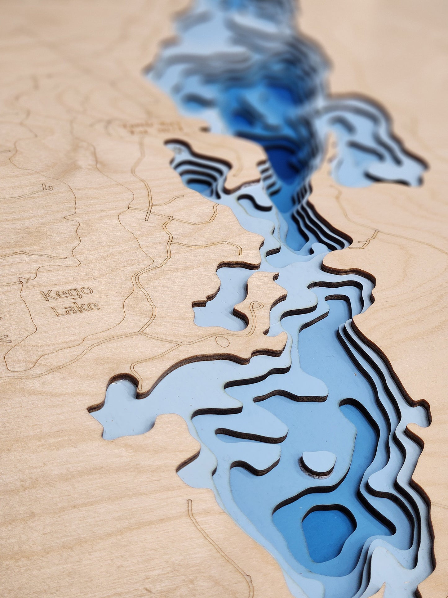
Lake Texoma on the Oklahoma-Texas Border
This lake has 8 Layers or 15 Layers for HD Version
Lake Texoma is an 89,000-acre reservoir formed by Denison Dam on the Red River, straddling the border between Oklahoma and Texas in Bryan County, Oklahoma, and Grayson County, Texas, approximately 726 miles upstream from the mouth of the Red River. Completed in 1944 by the U.S. Army Corps of Engineers for flood control, hydroelectric power generation, water conservation, and recreation, this massive impoundment is the 12th largest Corps of Engineers lake in the United States and the largest within the Tulsa District. The lake sits at the strategic confluence of the Red River from the west and the Washita River from the north, with additional water sources including Big Mineral Creek, Little Mineral Creek, Buncombe Creek, Rock Creek, and Glasses Creek. With 580 miles of irregular and branched shoreline, Lake Texoma features diverse habitat including rocky bluffs, sandy beaches, standing timber extending 50 miles along the shore, approximately 9 miles of riprap, submerged stump beds, creek channels, and coarse gravel flats. The conservation pool elevation varies seasonally from 615 to 619 feet above mean sea level, with an average depth of 40 feet and maximum depth of 100 feet near Denison Dam.
Lake Texoma has earned international recognition as the "Striper Capital of the World," distinguished as one of only a handful of inland lakes in the United States where striped bass reproduce naturally without requiring hatchery stocking. Originally introduced by the Oklahoma Department of Wildlife Conservation in 1965, stripers achieved documented natural reproduction in the lake's slightly brackish waters by 1974, and the self-sustaining population has thrived ever since, with the Red and Washita Rivers providing ideal spawning conditions each spring when stripers migrate up to 80 miles upstream. The lake attracts approximately 6 million visitors annually and supports a robust multi-million dollar fishing industry, offering exceptional year-round angling opportunities for striped bass, largemouth bass, smallmouth bass, spotted bass, white bass, blue catfish (including a former world record 121.5-pound specimen caught in 2004), channel catfish, flathead catfish, crappie, and numerous other species. Recreational facilities abound with 54 U.S. Army Corps of Engineers-managed parks, two state parks including Eisenhower State Park on the Texas shore and Lake Texoma State Park on the Oklahoma shore, 12 full-service marinas, 26 resorts, hundreds of campgrounds with primitive and RV sites, swimming beaches, hiking and biking trails, OHV trails, fishing piers, boat ramps, picnic pavilions, and numerous golf courses. The lake's proximity to the Dallas-Fort Worth Metroplex (approximately one hour north) and Oklahoma City makes it an easily accessible premier destination for power boating, sailing, personal watercraft, water skiing, wakeboarding, kayaking, paddleboarding, and the renowned Lakefest Regatta, widely considered the first inland charity regatta in the United States.
Dimensions:
Small: 8"x12"
Medium: 12"x18"
Large: 16"x24"
Extra Large: 20"x30"
XX Large: 24"x36"
Gigantic 30"x45"
HD Extra Large: 20"x30" - 15 Layers
HD XX Large: 24"x36" - 15 Layers
HD Gigantic 30"x45" - 15 Layers
The difference between standard and HD maps is the number of layers. Standard maps have 1 land layer and 7 water layers. The HD lake maps have 1 land layer and 14 water layers. So twice the detail. The HD Maps are limited to Extra Large, XX Large, and Gigantic sizes only. On the smaller sizes the depth change of the wood is too extreme and you end up losing detail.
Share