


Texoma (Bryan, Grayson)
Texoma (Bryan, Grayson)
Couldn't load pickup availability
Lake Texoma on the Oklahoma-Texas Border
This lake has 8 Layers or 15 Layers for HD Version
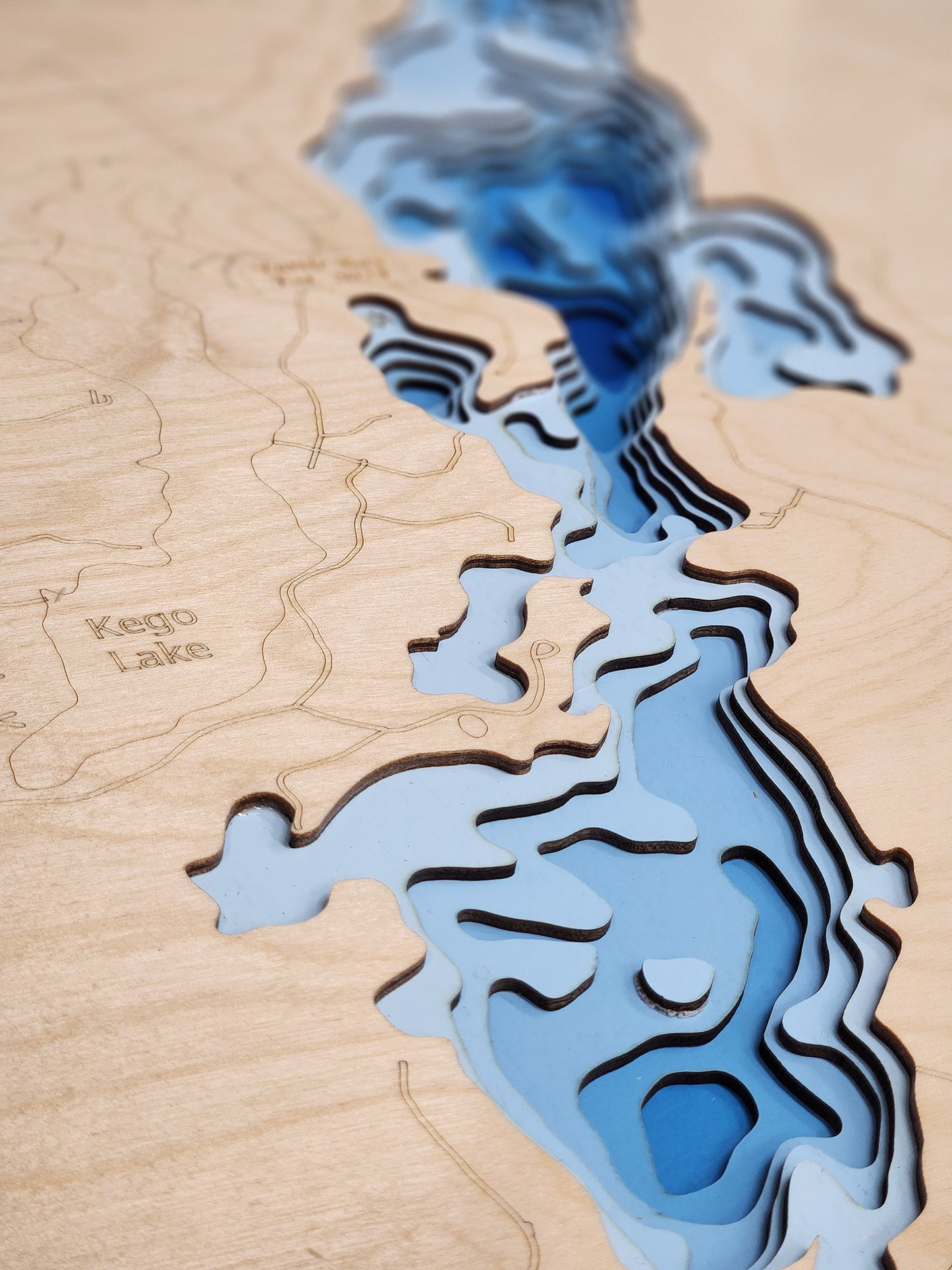
Lake Texoma is an 89,000-acre reservoir formed by Denison Dam on the Red River, straddling the border between Oklahoma and Texas in Bryan County, Oklahoma, and Grayson County, Texas, approximately 726 miles upstream from the mouth of the Red River. Completed in 1944 by the U.S. Army Corps of Engineers for flood control, hydroelectric power generation, water conservation, and recreation, this massive impoundment is the 12th largest Corps of Engineers lake in the United States and the largest within the Tulsa District. The lake sits at the strategic confluence of the Red River from the west and the Washita River from the north, with additional water sources including Big Mineral Creek, Little Mineral Creek, Buncombe Creek, Rock Creek, and Glasses Creek. With 580 miles of irregular and branched shoreline, Lake Texoma features diverse habitat including rocky bluffs, sandy beaches, standing timber extending 50 miles along the shore, approximately 9 miles of riprap, submerged stump beds, creek channels, and coarse gravel flats. The conservation pool elevation varies seasonally from 615 to 619 feet above mean sea level, with an average depth of 40 feet and maximum depth of 100 feet near Denison Dam.
Lake Texoma has earned international recognition as the "Striper Capital of the World," distinguished as one of only a handful of inland lakes in the United States where striped bass reproduce naturally without requiring hatchery stocking. Originally introduced by the Oklahoma Department of Wildlife Conservation in 1965, stripers achieved documented natural reproduction in the lake's slightly brackish waters by 1974, and the self-sustaining population has thrived ever since, with the Red and Washita Rivers providing ideal spawning conditions each spring when stripers migrate up to 80 miles upstream. The lake attracts approximately 6 million visitors annually and supports a robust multi-million dollar fishing industry, offering exceptional year-round angling opportunities for striped bass, largemouth bass, smallmouth bass, spotted bass, white bass, blue catfish (including a former world record 121.5-pound specimen caught in 2004), channel catfish, flathead catfish, crappie, and numerous other species. Recreational facilities abound with 54 U.S. Army Corps of Engineers-managed parks, two state parks including Eisenhower State Park on the Texas shore and Lake Texoma State Park on the Oklahoma shore, 12 full-service marinas, 26 resorts, hundreds of campgrounds with primitive and RV sites, swimming beaches, hiking and biking trails, OHV trails, fishing piers, boat ramps, picnic pavilions, and numerous golf courses. The lake's proximity to the Dallas-Fort Worth Metroplex (approximately one hour north) and Oklahoma City makes it an easily accessible premier destination for power boating, sailing, personal watercraft, water skiing, wakeboarding, kayaking, paddleboarding, and the renowned Lakefest Regatta, widely considered the first inland charity regatta in the United States.
Dimensions:
Small: 8"x12"
Medium: 12"x18"
Large: 16"x24"
Extra Large: 20"x30"
XX Large: 24"x36"
Gigantic 30"x45"
HD Extra Large: 20"x30" - 15 Layers
HD XX Large: 24"x36" - 15 Layers
HD Gigantic 30"x45" - 15 Layers
The difference between standard and HD maps is the number of layers. Standard maps have 1 land layer and 7 water layers. The HD lake maps have 1 land layer and 14 water layers. So twice the detail. The HD Maps are limited to Extra Large, XX Large, and Gigantic sizes only. On the smaller sizes the depth change of the wood is too extreme and you end up losing detail.
Share


About our Maps
Every map is designed and built in Minnesota. Nothing is outsourced and nothing is imported.
- Designed in-house. All art files are created by me, not purchased or reused
- True layered 3D construction. Not engraved or printed
- More layers, more detail. Most competitors use 3 to 7 layers. These use 8 or 15 layers
- Original blue depth gradient. Light to dark blue shows water depth clearly
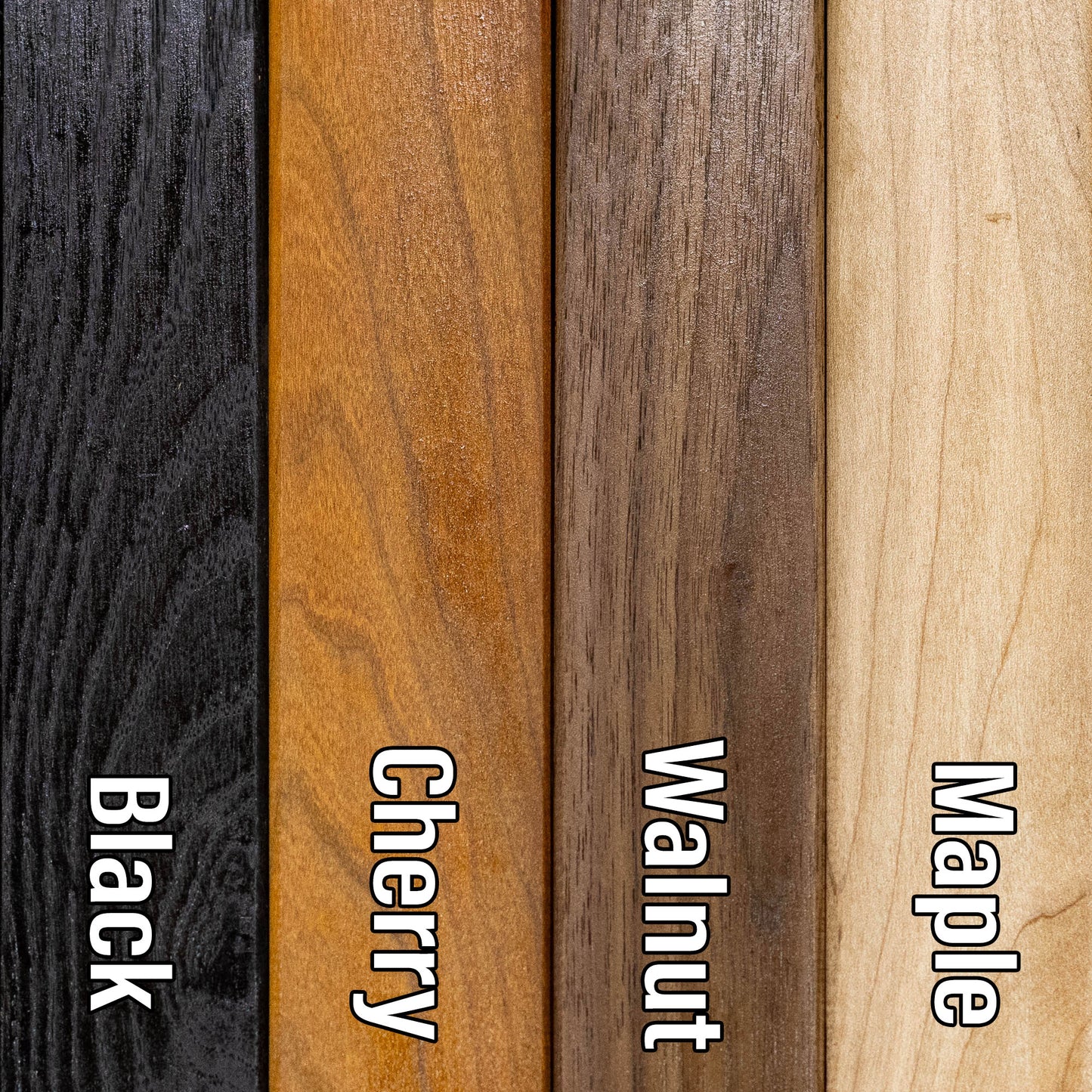
- Handmade hardwood frames. Built from locally sourced rough sawn lumber, not pre-made frames
These are built to be the most accurate and most detailed 3D lake maps available.
Horn Dog Maps vs Others
True layered 3D construction
Horn Dog Maps: Yes
Other Companies: No
Etsy Sellers: Sometimes
Designed in-house (no purchased files)
Horn Dog Maps: Yes
Other Companies: Sometimes
Etsy Sellers: No
Made in Minnesota
Horn Dog Maps: Yes
Other Companies: No
Etsy Sellers: No
Number of layers
Horn Dog Maps: 8 or 15
Other Companies: 3 to 7
Etsy Sellers: 3 to 7
Blue depth gradient water
Horn Dog Maps: Yes
Other Companies: No
Etsy Sellers: No
Handmade hardwood frame included
Horn Dog Maps: Yes
Other Companies: No
Etsy Sellers: No
Uses multiple depth data sources
Horn Dog Maps: Yes
Other Companies: Sometimes
Etsy Sellers: No
Custom lakes without delays
Horn Dog Maps: Yes
Other Companies: No
Etsy Sellers: No
Connection to the lakes
Horn Dog Maps: Yes
Other Companies: No
Etsy Sellers: No
Frequently Asked Questions
Are these actually 3D or just engraved?
These are true 3D layered maps.
- Made from 1/8 inch Baltic birch
- Standard maps have 8 layers. 1 land layer and 7 water layers
- HD maps have 15 layers. 1 land layer and 14 water layers
Each water layer uses a light to dark blue gradient so depth changes are easy to see.
Where are these made?
Everything is made in my shop in Minnesota.
- Design
- Cutting
- Painting
- Assembly
- Frame building
The frames start as locally sourced rough sawn hardwood and are built from scratch.
Do you use real depth data?
Yes, as an angler and map nerd, accuracy matters to me. I use multiple data sources, up to six, to find the most accurate lake contours available.
I would not hang an inaccurate map in my house and I will not send one to yours.
Why buy from Horn Dog Maps instead of Etsy or marketplace sellers?
Most marketplace sellers:
- Buy pre-made cut files, often from overseas
- Have no connection to the lakes
- Cannot verify accuracy
- Have long delays if a file is not available
This leads to lower accuracy and longer lead times, often 6 to 8 weeks.
Because I design everything myself:
- I can create a new lake mockup in about 30 minutes
- You get a more accurate map, faster
What is your lead time?
Most orders ship in 1.5 to 2 weeks depending on the time of year.
Tell me about the Cribbage Boards
These are different from the layered maps and are not something you will find elsewhere.
- Made from a solid piece of Maple or Cherry
- The lake is engraved as if drained
- Then filled with blue tinted epoxy that is still transparent
You can see:
- Channels
- Humps
- Points
- Structure
Additional features:
- 2 or 3 track options
- Choice of peg colors
- Hidden peg storage with a magnetic dovetail slider
- Rubber feet so it does not slide on the table
It is a functional game board and a detailed lake model in one.