


Winchester (St. Louis)
Winchester (St. Louis)
Couldn't load pickup availability
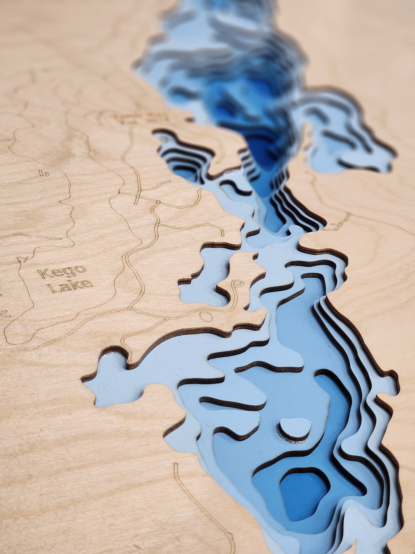
Winchester Lake in St. Louis County, Minnesota
This map has 8 layers
Winchester Lake is a 319-acre natural lake in St. Louis County, located approximately 12 miles east of Orr in the remote wilderness of northeastern Minnesota's Canadian Shield region. Featuring five miles of rugged, heavily forested shoreline with steep drop-offs and tannin-stained waters typical of shield lakes carved by ancient glaciers, the lake reaches a maximum depth of 50 feet with an average depth of 28 feet, creating diverse aquatic habitat from shallow bays to deep open water basins. Approximately 17 percent of the lake is less than 15 feet deep, with aquatic vegetation limited to a few shallow bays, while the lake bottom features dramatic structure including submerged timber at 80 to 90-foot depths that provide excellent cover for fish. Very little development exists on Winchester Lake, preserving its pristine wilderness character, with the only public access being a carry-in facility that ensures minimal impact and maintains the lake's remote, tranquil atmosphere. The Minnesota Department of Natural Resources manages Winchester Lake primarily as a trophy Lake Trout fishery, with stocking occurring annually from 2005 to 2009 and every other year thereafter to establish and maintain this unique cold-water population. A comprehensive fisheries survey was completed in 2019 as part of the regularly scheduled rotation of surveys in the International Falls Management Area, providing critical data to guide ongoing management strategies that balance fish populations with the lake's natural ecosystem and maintain exceptional angling opportunities for visitors seeking a true wilderness fishing experience.
Winchester Lake offers exceptional multi-species fishing opportunities in a pristine wilderness setting, supporting populations of Lake Trout that were successfully introduced through strategic stocking programs and now range from recently stocked fish less than 13 inches to impressive specimens reaching 28 inches from the original 2006 to 2009 year classes. The lake's cool, clear waters and abundant Cisco or Tullibee forage create ideal conditions for the very few Northern Pike present to achieve impressive growth rates, with the 2019 survey capturing three trophy-sized pike measuring 34.0, 41.5, and 42.6 inches in length, demonstrating the lake's capacity to produce monster-sized fish in this low-density, high-quality environment. Smallmouth Bass thrive in Winchester's rocky Canadian Shield structure, with lengths ranging from about 12 to 19 inches indicating excellent size structure, while panfish including Black Crappie, Bluegill, Pumpkinseed, Rock Bass, and Yellow Perch provide additional angling opportunities throughout the year. The carry-in access ensures that only those willing to portage their watercraft can reach this hidden gem, filtering out casual users and preserving the lake's wilderness character for serious anglers and paddlers seeking solitude and pristine natural beauty. Beyond fishing, the surrounding forest provides opportunities for wildlife observation including bald eagles, loons, deer, bears, and occasionally moose along the shoreline, while the clear waters invite exploration by canoe or kayak through the lake's numerous coves and around its forested islands. The nearby town of Orr, just 12 miles west, serves as the gateway to this region and offers supplies, lodging, and dining, while also providing access to remarkable attractions including the Vince Shute Wildlife Sanctuary where visitors can safely observe wild black bears from viewing platforms, the Orr Bog Walk featuring a half-mile handicap-accessible boardwalk through four types of Minnesota bogs with rare plants including the pink lady slipper, and Voyageurs National Park just 27 miles northeast, a primarily water-based park encompassing over 218,000 acres of interconnected waterways including Crane, Rainy, Kabetogama, and Namakan Lakes with hundreds of boat-accessible campsites, historic sites like the Ellsworth Rock Gardens and Kettle Falls Hotel, excellent fishing, paddling, and hiking opportunities, plus International Dark Sky Park designation for spectacular stargazing experiences.
Dimensions:
Small: 8"x12"
Medium: 12"x18"
Large: 16"x24"
Extra Large: 20"x30"
XX Large: 24"x36"
Gigantic 30"x45"
Share


About our Maps
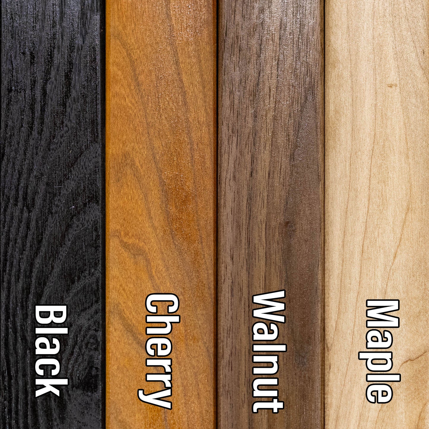
Every map is designed and built in Minnesota. Nothing is outsourced and nothing is imported.
- Designed in-house. All art files are created by me, not purchased or reused
- True layered 3D construction. Not engraved or printed
- More layers, more detail. Most competitors use 3 to 7 layers. These use 8 or 15 layers
- Original blue depth gradient. Light to dark blue shows water depth clearly
- Handmade hardwood frames. Built from locally sourced rough sawn lumber, not pre-made frames
These are built to be the most accurate and most detailed 3D lake maps available.
Horn Dog Maps vs Others
True layered 3D construction
Horn Dog Maps: Yes
Other Companies: No
Etsy Sellers: Sometimes
Designed in-house (no purchased files)
Horn Dog Maps: Yes
Other Companies: Sometimes
Etsy Sellers: No
Made in Minnesota
Horn Dog Maps: Yes
Other Companies: No
Etsy Sellers: No
Number of layers
Horn Dog Maps: 8 or 15
Other Companies: 3 to 7
Etsy Sellers: 3 to 7
Blue depth gradient water
Horn Dog Maps: Yes
Other Companies: No
Etsy Sellers: No
Handmade hardwood frame included
Horn Dog Maps: Yes
Other Companies: No
Etsy Sellers: No
Uses multiple depth data sources
Horn Dog Maps: Yes
Other Companies: Sometimes
Etsy Sellers: No
Custom lakes without delays
Horn Dog Maps: Yes
Other Companies: No
Etsy Sellers: No
Connection to the lakes
Horn Dog Maps: Yes
Other Companies: No
Etsy Sellers: No
Frequently Asked Questions
Are these actually 3D or just engraved?
These are true 3D layered maps.
- Made from 1/8 inch Baltic birch
- Standard maps have 8 layers. 1 land layer and 7 water layers
- HD maps have 15 layers. 1 land layer and 14 water layers
Each water layer uses a light to dark blue gradient so depth changes are easy to see.
Where are these made?
Everything is made in my shop in Minnesota.
- Design
- Cutting
- Painting
- Assembly
- Frame building
The frames start as locally sourced rough sawn hardwood and are built from scratch.
Do you use real depth data?
Yes, as an angler and map nerd, accuracy matters to me. I use multiple data sources, up to six, to find the most accurate lake contours available.
I would not hang an inaccurate map in my house and I will not send one to yours.
Why buy from Horn Dog Maps instead of Etsy or marketplace sellers?
Most marketplace sellers:
- Buy pre-made cut files, often from overseas
- Have no connection to the lakes
- Cannot verify accuracy
- Have long delays if a file is not available
This leads to lower accuracy and longer lead times, often 6 to 8 weeks.
Because I design everything myself:
- I can create a new lake mockup in about 30 minutes
- You get a more accurate map, faster
What is your lead time?
Most orders ship in 1.5 to 2 weeks depending on the time of year.
Tell me about the Cribbage Boards
These are different from the layered maps and are not something you will find elsewhere.
- Made from a solid piece of Maple or Cherry
- The lake is engraved as if drained
- Then filled with blue tinted epoxy that is still transparent
You can see:
- Channels
- Humps
- Points
- Structure
Additional features:
- 2 or 3 track options
- Choice of peg colors
- Hidden peg storage with a magnetic dovetail slider
- Rubber feet so it does not slide on the table
It is a functional game board and a detailed lake model in one.