


Chaubunagungamaug Lake in Worcester County, Massachusetts
Chaubunagungamaug Lake in Worcester County, Massachusetts
Couldn't load pickup availability
Chaubunagungamaug Lake in Worcester County, Massachusetts
This map has 8 layers
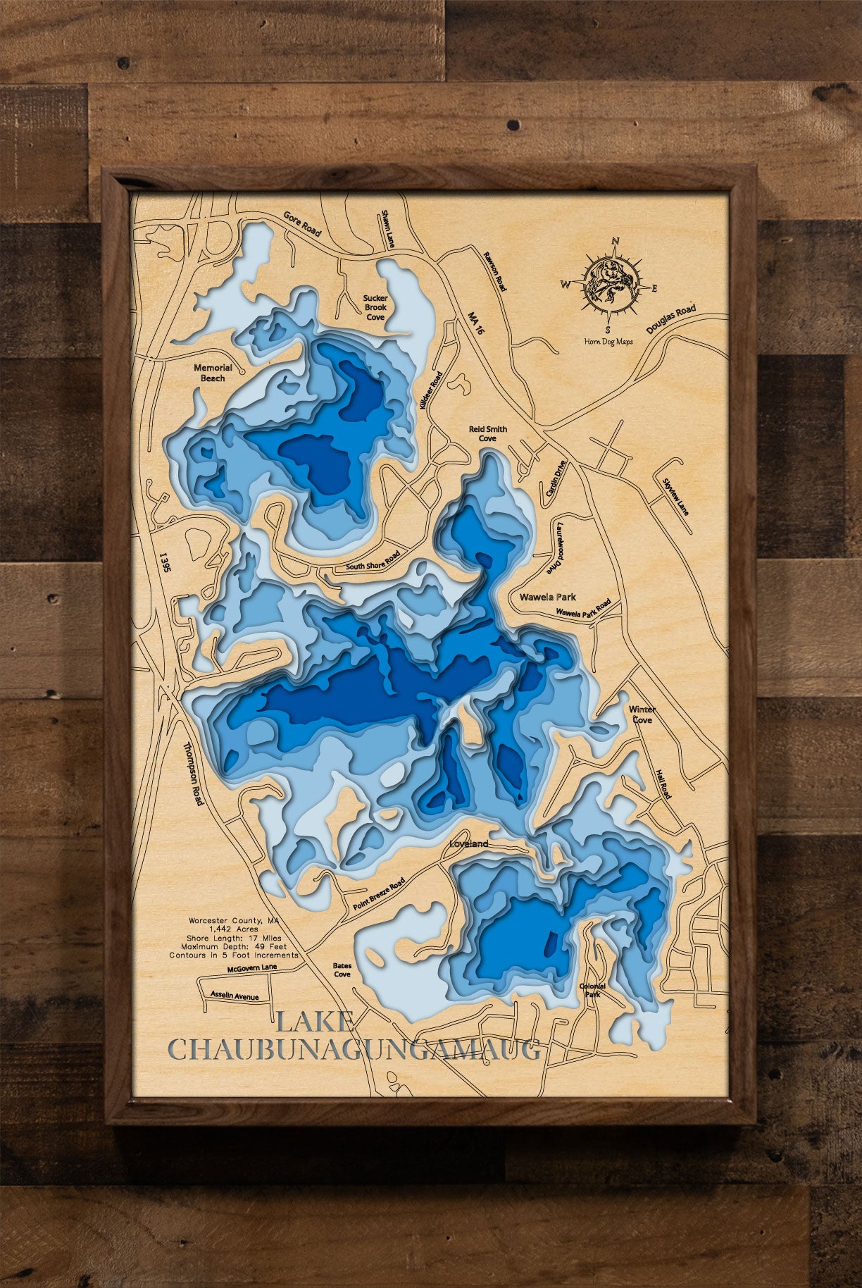
Lake Chaubunagungamaug, also known as Webster Lake, is a 1,442-acre lake located in the town of Webster, in Worcester County, Massachusetts. It is famous for having the longest name of any geographic feature in the United States. The lake has a maximum depth of 49 feet and an average depth of 13 feet. Its unique name is said to mean "You fish on your side, I fish on my side, nobody fishes in the middle."
This large lake is a popular recreational area, offering opportunities for boating, fishing, and swimming. Its complex underwater terrain, featuring deep holes and rocky shoals, supports a diverse fish population, including Largemouth Bass, Smallmouth Bass, Chain Pickerel, and various panfish. The shoreline is developed with private homes and some public access points. Despite its development, Lake Chaubunagungamaug remains a significant natural and recreational resource in southern Massachusetts
Dimensions:
Small: 8"x12"
Medium: 12"x18"
Large: 16"x24"
Extra Large: 20"x30"
XX Large: 24"x36"
Gigantic 30"x45"
HD Extra Large: 20"x30" - 15 Layers
HD XX Large: 24"x36" - 15 Layers
HD Gigantic 30"x45" - 15 Layers
The difference between standard and HD maps is the number of layers. Standard maps have 1 land layer and 7 water layers. " The HD lake maps have 1 land layer and 14 water layers. So twice the detail. The HD Maps are limited to Extra Large, " XX Large, and Gigantic sizes only. On the smaller sizes the depth change of the wood is too extreme and you end up losing detail.
Cribbage Boards - 10"x14" - Your choice of Maple or Cherry wood, 2 or 3 runs, and your choice of peg colors.
Share


About our Maps
Every map is designed and built in Minnesota. Nothing is outsourced and nothing is imported.
- Designed in-house. All art files are created by me, not purchased or reused
- True layered 3D construction. Not engraved or printed
- More layers, more detail. Most competitors use 3 to 7 layers. These use 8 or 15 layers
- Original blue depth gradient. Light to dark blue shows water depth clearly
- Handmade hardwood frames. Built from locally sourced rough sawn lumber, not pre-made frames
These are built to be the most accurate and most detailed 3D lake maps available.
Horn Dog Maps vs Others
True layered 3D construction
Horn Dog Maps: Yes
Other Companies: No
Etsy Sellers: Sometimes
Designed in-house (no purchased files)
Horn Dog Maps: Yes
Other Companies: Sometimes
Etsy Sellers: No
Made in Minnesota
Horn Dog Maps: Yes
Other Companies: No
Etsy Sellers: No
Number of layers
Horn Dog Maps: 8 or 15
Other Companies: 3 to 7
Etsy Sellers: 3 to 7
Blue depth gradient water
Horn Dog Maps: Yes
Other Companies: No
Etsy Sellers: No
Handmade hardwood frame included
Horn Dog Maps: Yes
Other Companies: No
Etsy Sellers: No
Uses multiple depth data sources
Horn Dog Maps: Yes
Other Companies: Sometimes
Etsy Sellers: No
Custom lakes without delays
Horn Dog Maps: Yes
Other Companies: No
Etsy Sellers: No
Connection to the lakes
Horn Dog Maps: Yes
Other Companies: No
Etsy Sellers: No
Frequently Asked Questions
Are these actually 3D or just engraved?
These are true 3D layered maps.
- Made from 1/8 inch Baltic birch
- Standard maps have 8 layers. 1 land layer and 7 water layers
- HD maps have 15 layers. 1 land layer and 14 water layers
Each water layer uses a light to dark blue gradient so depth changes are easy to see.
Where are these made?
Everything is made in my shop in Minnesota.
- Design
- Cutting
- Painting
- Assembly
- Frame building
The frames start as locally sourced rough sawn hardwood and are built from scratch.
Do you use real depth data?
Yes, as an angler and map nerd, accuracy matters to me. I use multiple data sources, up to six, to find the most accurate lake contours available.
I would not hang an inaccurate map in my house and I will not send one to yours.
Why buy from Horn Dog Maps instead of Etsy or marketplace sellers?
Most marketplace sellers:
- Buy pre-made cut files, often from overseas
- Have no connection to the lakes
- Cannot verify accuracy
- Have long delays if a file is not available
This leads to lower accuracy and longer lead times, often 6 to 8 weeks.
Because I design everything myself:
- I can create a new lake mockup in about 30 minutes
- You get a more accurate map, faster
What is your lead time?
Most orders ship in 1.5 to 2 weeks depending on the time of year.
Tell me about the Cribbage Boards
These are different from the layered maps and are not something you will find elsewhere.
- Made from a solid piece of Maple or Cherry
- The lake is engraved as if drained
- Then filled with blue tinted epoxy that is still transparent
You can see:
- Channels
- Humps
- Points
- Structure
Additional features:
- 2 or 3 track options
- Choice of peg colors
- Hidden peg storage with a magnetic dovetail slider
- Rubber feet so it does not slide on the table
It is a functional game board and a detailed lake model in one.